


- EDITIONS:
 Spanish News Today
 Murcia Today
 Alicante Today
PROPERTY SEARCH

No let-up from the storm as orange wind alerts hit eastern Andalucía
Gusts of up to 100 km/h and very rough seas forecast for parts of Almería, Granada and Jaén this Friday
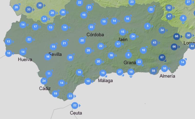 There is little sign of a break from unsettled weather in Andalucía, with strong winds and rough seas set to dominate conditions again this Friday January 30.
Weather warnings remain in place across several eastern provinces as the region continues to feel the effects of the ongoing storm. The most serious alerts relate to wind, with orange warnings issued for parts of Almería, Granada and Jaén, where gusts could reach between 90 and 100 km/h later in the day.
According to Spain’s State Meteorological Agency, Aemet, andthe warnings will change in both level and location as conditions evolve. An Aemet spokesperson warned that “the strongest gusts are expected during the afternoon and evening, particularly in exposed inland areas.”
Along the coast, conditions are also expected to be difficult. Strong westerly winds will make the sea very rough at times, with significant wave heights forecast along the coasts of Almería and Granada.
In Almería province, wind warnings begin at yellow level in the Almanzora Valley, Los Vélez, Nacimiento and Campo de Tabernas, remaining in force until 3.00pm. From that point, the alert is upgraded to orange until midnight, with gusts of up to 90 km/h expected. Elsewhere, including Poniente, Almería city and the eastern part of the province, yellow warnings apply from 11.00am until the end of the day, with gusts ranging from 70 to 80 km/h.
Sea conditions in Almería are also a concern. A yellow warning for rough seas is active from midnight until 7.00pm, before being raised to orange until midnight. Westerly winds of 50 to 60 km/h and waves of between three and four metres are forecast.
Granada will also see a marked deterioration later in the day. An orange wind alert is in place from 6.00pm until midnight in the Nevada and Alpujarras areas, where gusts could reach 100 km/h. At the same time, yellow warnings cover the Genil River Basin, Guadix, Baza and the coast, with gusts of up to 80 km/h. Coastal warnings apply in two separate periods, from midnight to 5.00am and again from midday onwards.
In Jaén, the Cazorla and Segura region is under an orange alert from 6.00pm until midnight, with gusts of up to 90 km/h. Yellow warnings cover the Guadalquivir Valley and Capital and Montes areas during the same period.
These latest warnings come after days of stormy weather that have already caused thousands of incidents and forced evacuations across Andalucía. Forecasters had already warned that the unsettled conditions would continue into the weekend, with strong winds remaining a key concern.
Emergency services continue to advise residents to take extra care, particularly when travelling, securing outdoor objects and staying well clear of exposed coastal areas while the warnings remain in force.
>>> Follow our Andalusia Weather Watch Facebook group for more weather news or see our Weather & Climate page <<<
Images: Aemet


staff.inc.and
Sign up for the Spanish News Today Editors Roundup Weekly Bulletin and get an email with all the week’s news straight to your inbox
Special offer: Subscribe now for 25% off (36.95 euros for 48 Bulletins)
OR
you can sign up to our FREE weekly roundup!
Read some of our recent bulletins:
Discount Special Offer subscription:
36.95€ for 48 Editor’s Weekly News Roundup bulletins!
Please CLICK THE BUTTON to subscribe.
(List price 3 months 12 Bulletins)
Read more stories from around Spain: