





- EDITIONS:
 Spanish News Today
 Murcia Today
 Alicante Today

PROPERTY SEARCH

Spain weather forecast August 24-27: Storms, sunshine and a sharp temperature drop
A stormy start to the week will be followed by calmer weather before another Atlantic system brings cooler temperatures and rain on Thursday
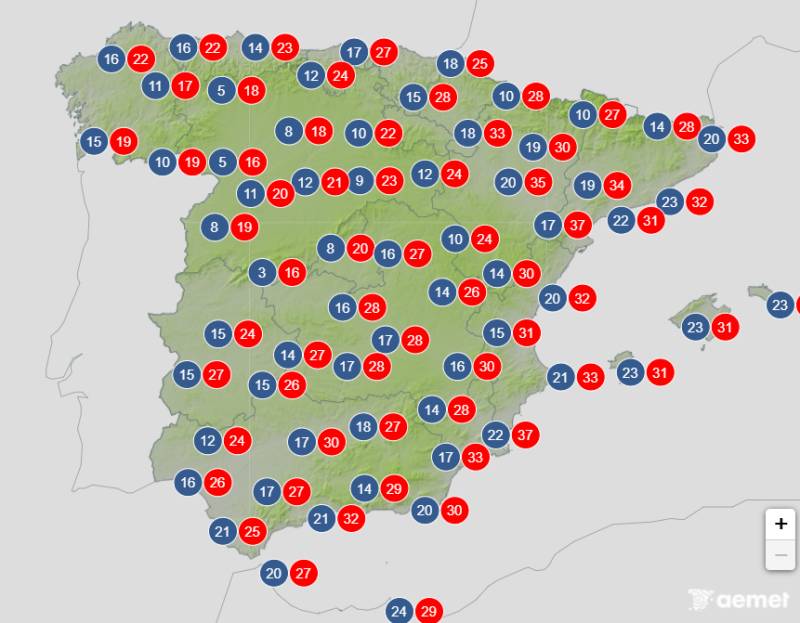
Average temperatures forecast for Thursday August 27
Spain is in for another dramatic change in the weather this week, with Monday bringing storms and heavy rain to parts of the country before calmer conditions arrive for a couple of days.
The respite won’t last long, however. A new Atlantic system is expected to move in from Thursday, bringing another drop in temperatures and the possibility of rain across much of Spain.
Monday August 24
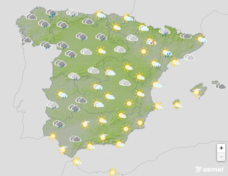
The week gets off to a distinctly unsettled start, particularly in the west and north of Spain.
The State Meteorological Agency (AEMET) is forecasting widespread cloud and rain across the western half of the country, with some areas seeing heavy and persistent downpours. Storms are also expected in the north-east and parts of the Mediterranean, where some could be particularly intense.
The weather will be rather different in the south-east, where there should be more sunshine.
Temperatures will generally fall, with the biggest drops expected across the western interior. However, parts of the Mediterranean coast will remain warm, with temperatures still exceeding 35°C in some inland and pre-coastal areas of the Levante.
Tuesday August 25
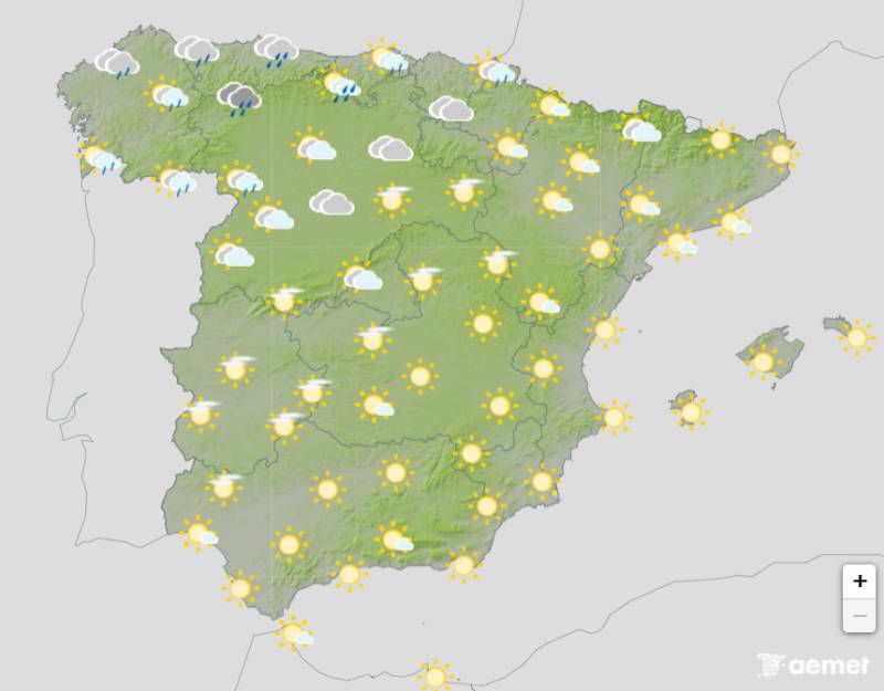
Things should calm down considerably on Tuesday as the first storm system moves away. The west and central parts of the country should feel noticeably fresher, while the north-east and Mediterranean coast remain warmer.
The north could still see some cloud and showers, but for anyone on the Mediterranean coast, Tuesday should feel much more like a typical August day, with sunshine and warmer temperatures returning.
Wednesday August 26
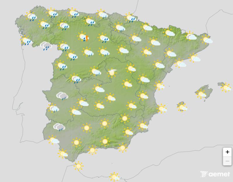
Wednesday is expected to be another relatively calm day for much of Spain, although there could still be some showers in northern and mountainous areas.
Temperatures should rise again in many places, particularly towards the east and south. The Mediterranean coast is likely to remain warm, while inland areas should also see temperatures climb following the cooler start to the week.
There is still some uncertainty around the exact location of showers and thunderstorms, particularly over northern Spain and mountainous areas.
Thursday August 27
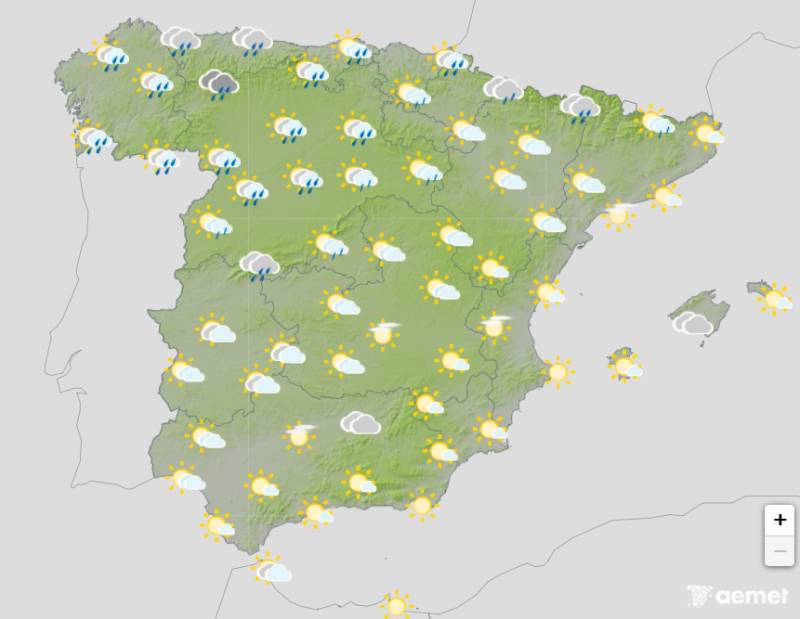
Thursday is when the next major change is expected.
AEMET is warning that another Atlantic low-pressure system could bring more autumn-like weather, with temperatures falling and rain becoming more widespread.
The drop is expected to be particularly noticeable in northern and central Spain. Madrid, for example, is currently forecast to see its maximum temperature fall from around 27°C on Tuesday and 28°C on Wednesday to around 23°C on Thursday, with a chance of rain.
The south and south-east should escape the worst of the rain, with areas such as Andalucía and Murcia remaining generally drier and warmer. However, temperatures are also expected to fall in many parts of the country.
For more weather news go to our Weather & Climate page or follow the Spain Weather Watch Facebook group for regular updates
Images: Aemet


staff.inc.and
Sign up for the Spanish News Today Editors Roundup Weekly Bulletin and get an email with all the week’s news straight to your inbox
Special offer: Subscribe now for 25% off (36.95 euros for 48 Bulletins)
OR
you can sign up to our FREE weekly roundup!
Read some of our recent bulletins:
Discount Special Offer subscription:
36.95€ for 48 Editor’s Weekly News Roundup bulletins!
Please CLICK THE BUTTON to subscribe.
(List price 3 months 12 Bulletins)
Read more stories from around Spain: