
- EDITIONS:
 Spanish News Today
 Murcia Today
 Alicante Today
Walking in Águilas: the Marina de Cope route
The SL-MU 23 walk includes wild beaches, a Roman jetty and a nuclear spring!
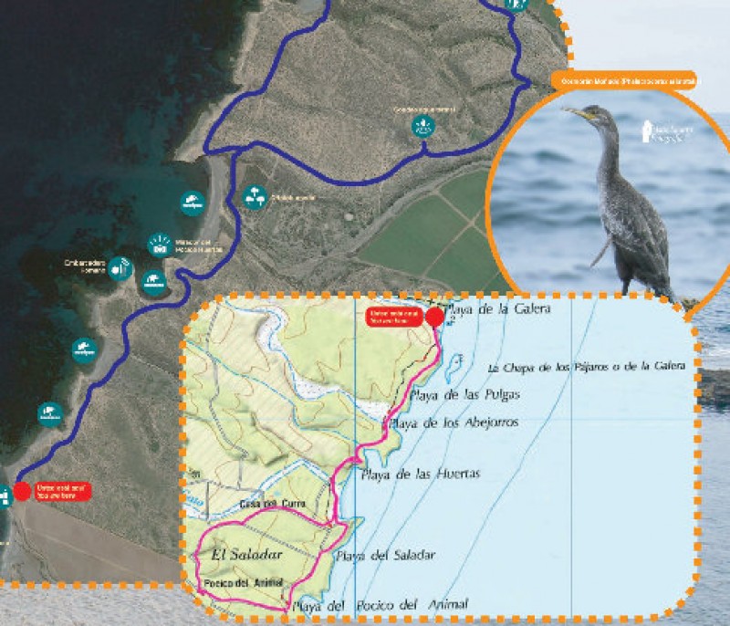
The route lies entirely within the Regional Park of Cabo Cope y Puntas de Calnegre, and allows walkers to appreciate the natural and cultural heritage which make the area deserving of this status. Along the way are nesting sites used by various bird species, beautiful coves, the remains of Roman settlements, a small crypto-wetland at the Playa del Saladar and even an opening in the ground from which a thermal spring flows.
The first part of the path follows a linear route and there is then a circular stretch, while part of the route also coincides with the long-distance GR-92 walking route (between Playa de la Galera and Playa del Pocico del Animal). The terrain does not present special difficulties for walkers.
After passing the first beach at the northern end of the route, the Playa de la Galera, it is possible to see the “Chapa de los Pájaros”, a small, flat islet often used by Audouin’s gulls and common cormorants to dry themselves in the sun. Both are endangered species, but here the population level is stable.
At the Playa del Saladar (or Playa del Salar) is an unusual wetland where the water does not reach the surface, sometimes referred to as a crypto-wetland. In these ecosystems the water remains just below ground, feeding the roots of plants, and when storms batter the coast seawater floods the area: the same occurs when floodwater flows down the rambla in which the wetland lies.
The soil consists mostly of marls and clays, which are highly impermeable, and it is this which causes the salty water to be trapped in the form of large puddles which, when they evaporate, leave behind salty crusts. For this reason the wetland is home to highly specialized species which are of great scientific importance due to their ability to survive in such extreme conditions, such as the Salsola papillosa plant.

One of the stop-off points along the route is the Roman jetty of Pocico Huertas, which nowadays consists of a suspiciously rectilinear rocky formation jutting out from the shore. Taking advantage of the protection from prevailing easterly winds, the Romans created the jetty here, and it was used for the maritime transportation of minerals extracted from the nearby mountains to large ports such as Águilas and Cartagena.
Another is the “nuclear spring”: in 1973, acting on the instructions of General Franco’s government, the publicly owned company Hidroeléctrica Española attempted to build a nuclear power station here, but the project was never carried out due to numerous technical difficulties and to considerable opposition to the plans from the Town Halls of Águilas, Lorca, Mazarrón and Pulpí.
However, evidence of the episode can still be seen in the form of the tall metal tower which stands above meteorological and seismic monitoring equipment, and a hole in the ground: this hole, which is above a thermal spring, is one of various soundings which were made, some of them reaching depths of 170 metres, to collect geo-seismic data.
SL-MU 23
Length: 4.7 km
Ascent and descent: 33 metres
Estimated duration: 1 hour 40 minutes
Start and finish: the beach of Playa de la Galera
Main image: JC Escaravajal
Click for the Wikiloc route map, or for more information about the municipality of Águilas visit Águilas Today.
staff.inc.and


